Review System
6.1 The best way to define the timing of strategic infrastructure is via a CTS type study, but the current situation illustrates that this is not always possible. The CTS-3 Final Report will follow on ten years after that of CTS-2, with the CTS-2 Update forming an intermediate information point. It would be very useful to review the need, timing, scope and priorities of the projects recommended in CTS-3, taking into account the changes that will undoubtedly occur in the planning and development of Hong Kong.
6.2 The methodology adopted for the review focuses on those factors that are most significant in defining the traffic demand in the corridor of a new transport infrastructure project. The factors for highways will depend on the location of the project and include some or all of:
|
|
|
|
|
|
|
6.3 Circumstances justifying a review have to be determined by professional judgement, but the onset of travel speed reduction may be a good indication for the need to take a closer look at individual projects. Environmental impact is taken as a constraint in achieving a sustainable transport system rather than as an explicit factor.
6.4 It will be necessary to do sufficient advance works so that projects can be accelerated if shown necessary in subsequent review. This should involve the early commissioning and completion of the feasibility, investigation and possibly preliminary design studies. This will have the additional benefit of providing timely inputs to any reclamation or district studies that may impact on the land needed for the highways. In the case of rail projects a similar review may be worth consideration by RDS-2.
Allowing Room for Expansion
6.5 Most new projects in Hong Kong have been built to a size that historically their capacity is reached within a few years of opening. This typically has great advantages for projects to be privatised since they recoup much of their revenue in the financially important early years. In contrast, in places such as the USA and UK, projects are planned to have a 20-year life from opening before reaching capacity. This practice was seldom pursued in Hong Kong because of the relatively high rate of growth and the degree of suppressed demand.
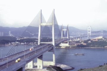
Example of new transport infrastructure
6.6 While the Hong Kong procedure of building for a relatively short term time horizon has never been defined as a policy, historically it was so because of the continuous high growth rate in both economy and population. Budgetary constraints have also been an ancillary factor. Indeed, economic and financial analyses have often been used to show that this procedure gives the best result. But there is an implicit underlying assumption in those analyses that the demand that will occur beyond the period of analysis can be satisfied in some undefined manner. Up to now this has led to the frequent need to find new road and rail alignment corridors. So far, this has been achieved successfully, but such opportunities are becoming increasingly scarce. It is no longer possible to assume that a new corridor will always be available, and so Hong Kong must now plan to make the best use of the corridors currently identified.
6.7 In order to make the best use of the transport corridors that have currently been identified and will be identified in the future, it is necessary to provide for the demand that may need to be accommodated in those corridors in the long term. This has been one of the objectives of CTS-3. The highways and railways can then be built to the size that the corridor and its associated feeder infrastructure can accept. It may be possible to stage the construction in some cases and thus save on initial costs, but this is difficult when extensive tunnels and structures are involved.
6.8 Construction of infrastructure in this manner would be an investment in the future of Hong Kong. The aim is that, wherever possible, transport facilities in major corridors should be built with long term growth in mind. In general, for a two track railway the capacity is large and will satisfy demand far into the future, and the option of increasing capacity is not worthwhile. However, for roads there is a much greater flexibility in selecting the cross-section. CTS-3 recommends that, especially where a corridor is not planned to be served by railway, extra funds should be spent to pave the way for future expansion in order to allow continued economic growth.
Comparison between Railway and Road Infrastructure
6.9 Railways serve a different purpose to roads, and cannot be seen as a direct substitution. The function of passenger rail lines in general is to allow the more intensive development of parts of the urban area, and to allow passengers a greater degree of mobility. However, the construction of railways can be a vital precursor to any reduction in road passenger traffic. They render the restraint of road traffic more palatable and more effective, by providing a good alternative to all forms of road passenger transport.
6.10 In terms of infrastructure, it must be recognised that highways and railways perform relatively separate functions which can be inter-related. The roads are essential for the commercial vehicle operations, not only for the transport of freight, but also for the use of the service and delivery industries, and emergency vehicles. These functions cannot easily switch to a rail system. Even for passenger transport in the inefficient taxi and car modes, it is not always possible to replace their use by rail unless the road system is too costly to use (e.g. very congested or parking provision severely restricted) which is considered unacceptable by CTS-3 from the mobility angle. Furthermore, there are always some ultimate origins and destinations not conveniently located relative to rail stations which have to be served by the road system. The major advantage of roads is their inherent flexibility, in that they can accommodate movements of different types of vehicles between different origin-destination pairs, but often at a high economic and environmental cost. On the other hand, railways are extremely effective at moving large numbers of people between fixed major centres of activity. It is also important to provide a mass carrier for a large sector of the population in major dormitory areas, who cannot afford or choose not to own cars. An extensive and well operated railway network together with an adequate road network accompanied by appropriate traffic demand management measures are essential components of an efficient transport system.
6.11 Both rail and road projects are evaluated using the same set of criteria including operational, economic, financial, budgetary, environmental, public acceptability and developmental considerations.
Development of Road Infrastructure
6.12 Even with a policy of according priority to rail, additional road infrastructure will be required. CTS-3 has examined the needs for new highways under various scenarios of population, vehicle fleet size and GDP growth as reflected in Table 6.1. The evaluation criteria used have been described earlier in this Report, and the objective has been to develop a road system under each scenario that satisfies demand in a cost-effective manner. Much of the demand for highways is due to the needs of commercial vehicles and private cars, but taxis also contribute significantly. The most efficient road users, buses and minibuses, form the smallest proportion of road usage, which decreases slightly in the future as the rail system is expanded.
6.13 CTS-3 was charged with addressing 'strategic' transport system problems, typically associated with longer distance travel between districts of Hong Kong. The planning of local road systems, serving intra-district demands is best addressed through district level planning studies.
6.14 As described in Chapter 2, CTS-3 considered a range of possible development and related travel demand growth scenarios. Road infrastructure improvement programmes were defined for three growth scenarios, low, medium and high. The road infrastructure programmes meet mobility objectives, given their associated demand forecasts.
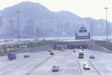
Road infrastructure for strategic transport system
6.15 Figures 6.1 through 6.3 show the low, medium and high road infrastructure programmes. Table 6.1 lists the individual projects, their costs and implementation period under each growth scenario. Differences between these infrastructure programmes consist primarily of different implementation year recommendations (later years under lower growth scenarios; some projects may even be needed only after 2016).
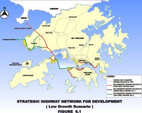
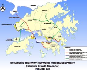
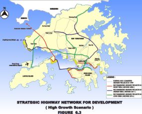
Table 6.1
Strategic Highway Projects By Scenario
| Strategic Highway Projects | Cross Section | Estimated Cost HK$bn (1998 prices) | Timing of projects 4 | ||
| Low Growth Scenario | Medium Growth Scenario | High Growth Scenario | |||
| Hong Kong Island | |||||
| Island Western Corridor | D2/3 | 2.6 | - | M | M |
| Central - Wan Chai Bypass and Island Eastern Corridor Link 1 | D2/4 | 10.6 | S | S | S |
| Route 7 (Kennedy Town to Aberdeen) 2 | D3 | 9.7 | S | S | S |
| Hong Kong North Shore Bypass | D3 | 13.0 | - | - | L |
| Harbour Crossings | |||||
| Fourth Harbour Crossing | D3 | 6.6 | - | L | L |
| Kowloon | |||||
| Central Kowloon Route | D2 | 7.6 | S | S | S |
| Trunk Road T1 (Hung Hom – Tate's Cairn Link) | D2 | 2.1 | - | L | L |
| Trunk Road T2 (Kai Tak Connector) | D3 | 3.2 | M | S | S |
| NT West | |||||
| Route 10 (Tsing Lung Tau to Yuen Long) | D3 | 13.9 | S | S | S |
| Route 10 - So Kwun Wat Link Road | D2/3 | 3.5 | S | S | S |
| Deep Bay Link | D3 | 7.5 | S | S | S |
| Tuen Mun Port Expressway | D2/3 | 7.5 | L | M | M |
| Tuen Mun Southern Bypass | D2/3 | 5.2 | L | M | M |
| Tuen Mun Western Bypass | D2 | 11.4 | L | L | L |
| East – West Link | D3 | 12.7 | - | L | M |
| Tai Mo Shan Link | D2/3 | 12.5 | - | - | L |
| Kowloon Northern Bypass and Extension | D3 | 21.0 | - | - | L |
| NT East | |||||
| Tseung Kwan O, Western Coast Road | D3/4 | 4.8 | S | S | S |
| Eastern Highway (Southeast Kowloon to Fanling) | D3 | 26.5 | - | L | M |
| Eastern Highway (Fanling to Boundary) | D2/3 | 8.4 | - | - | L |
| Lantau Crossings | |||||
| Route 10 (North Lantau to Tsing Lung Tau) | D3 | 9.8 | S | S | S |
| Route 10 Hong Kong Lantau Link | D3 | 27.9 | L | M | M |
| Tuen Mun - Chek Lap Kok Link | D3 | 16.4 | - | L | L |
| Lantau Island | |||||
| Chok Ko Wan Link | D2/3 | 4.5 | S | S | S |
| Cross Boundary | |||||
| Shenzhen Western Corridor 3 | D3 | - | S | S | S |
| Lingdingyang Bridge 3 | D3 | - | L | M | M |
| Notes: | |
| 1. | Central - Wan Chai Bypass and Island Eastern Corridor Link is currently planned for completion by 2010 because of the unavailability of land. However, CTS-3 recommends these projects be implemented by 2006 as far as possible to relieve the anticipated congestion. |
| 2. | Route 7 (Kennedy Town to Aberdeen) is currently planned for completion by 2010 because of the unavailability of land. However, CTS-3 recommends to fasttrack the project for completion by 2006 as far as possible to improve mobility. |
| 3. | The implementation programmes of Shenzhen Western Corridor and Lingdingyang Bridge are subject to separate review. |
| 4. | The need and timing of individual road projects are indicative only. |
| S denotes project required around 2006. | |
| M denotes project required around 2011. | |
| L denotes project required around 2016. | |
| - denotes project not required until after 2016. | |
6.16 The primary purpose of most projects in the road improvement programme is to provide needed access to increased levels of development in the New Territories and on Lantau Island. These projects also provide improved connections to major cross boundary points. Additionally, two urban corridors are recommended for major improvements: the north/northwest shores of Hong Kong Island and an east-west corridor running from central Kowloon through the proposed reclamation around Kai Tak to Tseung Kwan O.
6.17 CTS-3 finds that with the timely and co-ordinated implementation of appropriate transport infrastructure, public transport services and traffic management measures, the mobility level can be maintained and even improved under the three growth scenarios tested in the Study, as compared with that of the 1997 base year.
6.18 Regarding implementation of the strategic highway projects, CTS-3 recommends consideration be given to developing a review system to ensure that their need, timing, scope and priorities are re-assessed before implementation in light of the latest development.
6.19 The road improvement programmes set out were identified based on development plans that included extensive land reclamations and related residential and commercial development. However, the public has become more conscious about the environmental and other potentially adverse impacts of these reclamations. The extent to which some of these reclamations would proceed has not yet been decided.
6.20 In order to provide a robust transport framework, two scenarios were defined to examine the impacts of reduced reclamations and related development. The first (the northern bias test) moved a portion of the residential and commercial development planned for the reclamations to the New Territories.
6.21 The second (the Lantau bias test) replaced the container port planned for Lantau with primarily residential development. The Lantau container port activities were relocated to the Tuen Mun Port. A portion of the planned reclamation residential and commercial development was relocated to Lantau. This test also included relocation of some planned reclamation commercial development to the New Territories. A slight decline in Hong Kong Island and Kowloon travel demands was noted in both reduced reclamation tests. However, the reductions were not sufficient to reduce strategic infrastructure needs in these areas.
6.22 The northern bias test produced additional traffic in the Yuen Long Highway corridor and on roads linking Fanling/Sheung Shui with the rest of the region to the south. Under this set of development assumptions these roads will probably experience capacity deficiencies in 2016, even with the improvements included in the recommended road programme. Should this development plan move forward additional investigation will be required to identify policy and/or infrastructure programmes to address these increased travel demands.
6.23 The Lantau bias test found an increase in road traffic to/from Lantau. However, these increases would still be within the capacity provided by the 2016 road programme. Additional demand would also be generated on the passenger rail lines serving the Island. These new demands would increase the capacity deficiency projected for the Tung Chung Line in 2016. The increased rail demand would enhance the performance of the Outer Western Corridor Rail Line. The test found an 80% increase in this line's ridership associated with the revised development assumptions.
6.24 Sensitivity tests were undertaken to determine the impacts of different GDP growth assumptions. Given that other forecasting assumptions remain constant, it was found that a shortfall in GDP of 10% in 2006 would produce a decline in road traffic ranging from 3% to 9%, depending on location. This could have the effect of pushing back the opening dates recommended above by 2 to 3 years.
Cross Boundary Implications
6.25 In anticipation of a rapid growth in cross boundary travel demands between Hong Kong and other places in the Pearl River Delta, co-ordination of cross boundary infrastructure will play a more significant part in the transport planning of Hong Kong. The issue of the provision of cross boundary links has been studied in the Crosslinks Further Study, and the role of CTS-3 was to examine the implications for the transport system of Hong Kong. For highways, this study has assumed that Shenzhen Western Corridor will be in place before 2006. Increases in cross boundary traffic, together with developments in Hong Kong, necessitate significant new infrastructure in NWNT, such as Route 10 and the Deep Bay Link. For rail, the assumption is that additional cross boundary capacity will be available linking to the KCR East Rail before 2006.
6.26 Cross boundary traffic forecasts were provided to CTS-3 by the Crosslinks Further Study. The 2016 estimates ranged from 85 to 164 thousand vehicles per day (the medium assumption used in most tests was 120 thousand vehicles per day). Almost all of the variations in volume was forecast for the two new crossings, the Lingdingyang Bridge (13 to 32 thousand vehicles per day) and the Shenzhen Western Corridor (35 to 95 thousand vehicles per day).
6.27 The range of volumes shown is all within the recommended capacities of the Hong Kong side approach roads (the Tuen Mun Port Expressway and the Deep Bay Link) to these two boundary crossings. The Crosslinks Further Study has also reported a large degree of uncertainty concerning the programme and forecasts for the Lingdingyang Bridge. Should the lower end of the range of volumes actually occur then the need and capacity of the approach roads would have to be reviewed. As such, the growth in cross boundary traffic should be closely monitored.
Funding Consideration
6.28 The transport infrastructures for the three scenarios have been drawn up based on the estimated available infrastructure budget derived by CTS-3. Funds available are assumed to increase in line with GDP.
6.29 Two budget levels were projected in CTS-3. The low budget corresponds to the average level of Government expenditure on infrastructure in recent years excluding the Airport Core Projects (ACP), whereas the high budget includes the costs of the ACP.
Note: The information of the report was valid at the time when it was published. It might not remain so as at the date when this webpage was reviewed / revised. Please refer to the first page of the report for its publication date.